
![]() Download EMIGMA Ground Complete Description
Download EMIGMA Ground Complete Description
Download DEMO database for Varied Applications
(works with our EMIGMA Demo)
Click image to enlarge
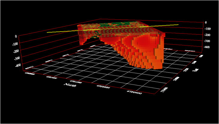
3D Resistivity Inversions
for ground surveys
Magnetics, Gravity;,
FDEM, TDEM;
IP/Resistivity, CSEM/CSAMT
for Windows 7/8/10/11
Data Imports
- Large Loop TDEM systems (e.g.SMARTem, Geonics, Zonge, UTEM, Crone)
- Small loop TDEM systems (terraTEM, TEM-FAST, Phoenix TEM and WTEM)
- FDEM Ground Imports (e.g.EM31/38, CMD Explorer, GSSI, MaxMin, Promis)
- AMIRA TDEM (SMARTem, Loupe, SIROTEM)
- Time Domain IP (Zonge, GDD, ELREC, Scintrex)
- Frequency Domain IP (Zonge, Generic)
- Resistivity Data (Generic, IRIS)
- Gravity Data (Scintrex, Micro-G, ASCII XYZ)
- Magnetic Data (e.g. GEM, Geometrics, Scintrex, SeaSPY)
Data Management
- Database backbone
- Large data set handling: three levels of data organization inside a database
- Merging, export, import of data sets and their customization for further use in EMIGMA modeling
- Data statistics
Data Processing and Correction
- 1D and 2D digital and spatial filters [user controls]
- Simple and statistically weighted averaging decimation
- FFT/DFT tools for magnetic/gravity data applicable to both measured and simulated data
- Graphical data extraction, profile editing and modification
- Survey Editor tools for cleaning and extraction
- Magnetic Base Station corrections
- Full suite of Gravity Corrections
- Latitude/Longtitude projections including polar projections
- Average duplicates, remove outliers, merge lines or surveys
- Regional trend removal
- Tie line corrections
3D Modeling
- Easy model building: large data sets, flexible profile generation and manipulation, multiple system geometries, large loop modeling, etc.
- Thin Sheet Plates, prism, polyhedra and spheric anomalies suitable of EM, Magnetic, Resistivity, Gravity, IP, CSEM, CSAMT data
- Multiple target shapes: pipes (hollow cylinders with or without lids), ellipsoids, shells, bullets, landmines, drums, spheres, prisms, plates, general polyhedra...
- Multiple scattering modeling: Simple Superposition, Far- and Near-Field Interaction, Automated Mode (the type of interaction is selected for you)
- Synthetic Topography-Poly Generator for modeling complex geological anomalies and topography
- Modeling conductors with volume Sphere and ILN prisms - Volumetric Induction Modeling
- Model suite generation for rapid building and running of layered earth and plate model suites with varying resistivity, thickness, strike, strike length, dip, dip extent, plunge and conductance
- 3D forward simulation in batch mode: multiple sources, any number of profiles, any number of data components
- Import of geological models from CAD applications
- Model building tools in 3D space
Data Inversion
- 1D inversion for EM and Resistivity data, TDEM not limited to IN LOOP surveys
- 3D inversion for Magnetics and Gravity including topographic effects
- 3D inversion for Resistivity and CSEM/CSAMT
- 3D Thin Sheet Plate inversion for TDEM and FDEM
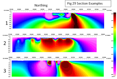
- Inversion grid editing and plane and cross section viewing
- 2D representation of geoelectric sections
- Magnetization vector inversions
3D Euler Deconvolution
- Statistical and Rodin post-processing
- 2D and 3D visualization of solutions
2D and 3D Visualization
- Data visualization in 3D, as profiles, vectors, true 3D surfaces or contoured surface combined 3D structure display
- 3D modeling tools: easy object manipulation and adjustment, single-click conversion of prisms to polyhedra, etc.
- 2D and 3D visualization of inversion results
Plotting
- Comprehensive XY Plotter for plotting data profiles, decays, spectrum, separations
- Multi-channel and multi-profile plotting
- Switching between channels, profiles and models
- Plotting to scale
- Multiple plots per page
- Residual plotting
- Saving plotting defaults for rapid plotting of model suites
- FOM algorithm for data quality control
Gridding
Click image to enlarge
Gridded DFT Upward Continue Data
- Rectangular grid cells to maintain spatial resolution along profiles
- Multi-parameter grids containing the complete set of survey frequencies, time windows, components, separations allowing comprehensive, rapid data examination
- Five gridding algorithms: Natural Neighbor, Delauney Triangulation, Shepard, Minimum Curvature and Thin-Plate-Splines
- Graphic controls of grid geometry and grid cell dimensions
Grid Presentation and Analysis
- Multi-component grids - switching between channels and components without the necessity to manage multiple grids
- Rectangular grid cells
- Profile, data and contour overlays
- Equal Weight and Equal Range display
- Euler solution overlays
- Decay rate/Amplitude mapping and export
- Superposition with raster maps and annotation
- Map generation with options for transparency and annotation
- Import and export of GeoTIFF format
- MultiGrid tool - viewing and comparing up to 4 grids simultaneously
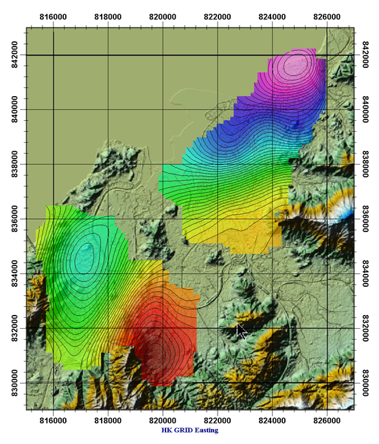
3D Contouring and Mapping
- Data display as 3D surfaces
- Range of pseudo-depth and pseudo-section displays
- 3D volume interpolation of inversion results - section cutting
Last updated Nov 2025