
Download Example demo database
(works with our EMIGMA Demo)
Click image to enlarge
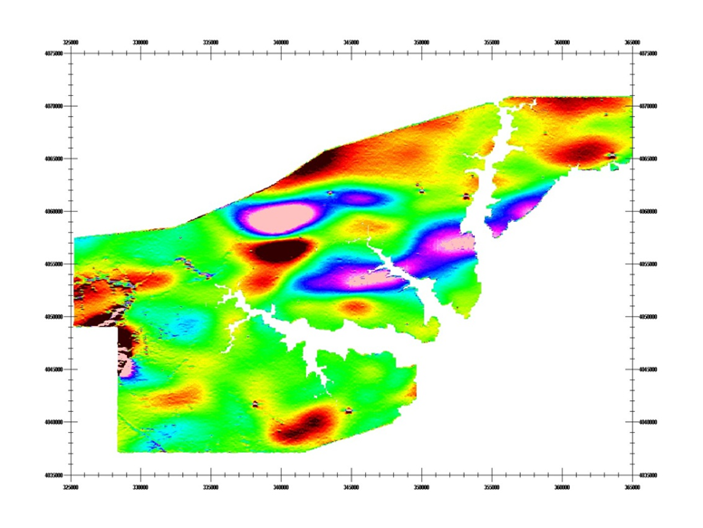
Contoured Data
Software for Magnetics, FEM, TEM, Gravity, IP, Resistivity, VLF/VLF-R including Airborne FEM and TEM capabilities
(does not include MT, CSEM or MTEM but these are available as add-ons)
Unlimited Survey Size!
GUI Interface - Intuitive User Interfaces for Windows Vista/7/8/10/11
Data Imports
- Large Loop TEM Imports (Geonics, Zonge, UTEM and Crone)
- Small loop systems (terraTEM, TEM-FAST, Phoenix TEM and WTEM)
- FEM Imports (Ground and Airborne)
- Airborne TEM (GeoTEM/MegaTEM, HeliTEM, TEMPEST, VTEM, and AeroTEM)
- AMIRA TEM (SmarTEM, SIROTEM)
- DC Magnetic, DC Magnetic Gradients (QCTool format, XYZ format, Scintrex Smartmag and Envi-Mag, NavMag, borehole, airborne systems - helicopter or fixed wing)
- Picodas, Pico binary formats
- Time Domain IP (Zonge, ELREC6 format, ASCII text format)
- Frequency Domain IP (Zonge and ASCII text format)
- Resistivity Data (Generic ASCII text file)
- MT data (QCTool, Zonge and ASCII text format)
- Gravity Data (QCTool and XYZ format) including full tensor gradients
- ZTEM/AFMAG Data (QCTool format)
- MTEM data (QCTool and SEGY formats)
- MMR data (Crone format)
Data Management
- Database backbone
- Large data set handling: three levels of data organization inside a database
- Merging, export, import of data sets and their customization for further use in EMIGMA modeling
- Geophysical data statistics
Data Processing and Correction
- 1D and 2D digital and spatial filters, with sizes specifiable by the user
- Simple and weighted averaging decimation
- FFT tools for gravity and magnetic data applicable to both measured and simulated data
- Graphical data extraction, profile editing and modification
- Data Corrector tool combining dynamic spreadsheets and line plotter for data cleaning, missing data interpolation and simultaneous plotting of different data channels for fast cross-analyses
- Magnetic base station correction
- Latitude/Longtitude projections including polar projections
- Average duplicates, remove outliers, merge lines or geophysical surveys
- Trend removal
3D Modeling
- Easy model building: large data sets, flexible profile generation and manipulation, multiple system geometries, large loop modeling, etc.
- Unlimited plate, prism and polyhedra anomalies suitable of EM, Gravity, Magnetic, IP, Resistivity, MT and CSAMT data
- Multiple target shapes: pipes (hollow cylinders with or without lids), ellipsoids, shells, bullets, landmines, drums, spheres, prisms, plates, general polyhedra...
- Multiple scattering modeling: Simple Superposition, Far- and Near-Field Interaction, Automated Mode
- Synthetic Topography-Poly Generator for modeling complex geological anomalies and topography
- Modeling conductors with volume ILN prisms - Volumetric Induction Modeling
- Model suite generation for rapid building of layered earth and plate model suites with varying resistivity, thickness, strike, strike length, dip, dip extent, plunge and conductance
- 3D forward simulation in batch mode: multiple sources, any number of profiles or boreholes, any number of data components
- Import of geological models from CAD applications
- Model building tool in 3D space
- Sphere algorithm, new inductive plate algorithm
Data Inversion
Click image to enlarge
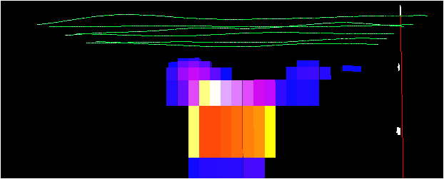
3D Inversion Section
- 1D inversion for EM, CSEM/CSAMT, MT, Resistivity data - inversions can be interpolated to a 3D volume
- 3D inversion for MT, Resistivity, Magnetics and Gravity
- Section cutting of 3D model volumes in the 3D Visualizer
- 2D representation of geoelectric sections - PEXShow tool
- Magnetization vector inversions
3D Extended Euler Deconvolution
- Statistical and Rodin spatial post-processing
- 2D and 3D visualization of solutions
- Magnetization inversion for angle and position
CDIMAP
Click image to enlarge
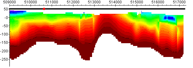
CDI Section
- Apparent Resistivity Tool - a half-space mapping technique for generating apparent resistivities as a function of frequency
- Sengpiel Depth-Sections - a resistivity pseudo-section technique for generating resistivities as a function of pseudo-depths
2D and 3D Visualization
- Data visualization in 3D space, as profiles, vectors, true 3D surfaces or contoured surface along with the 3D structure display
- Ability to view up to three data channels
- 3D modeling tools: easy object manipulation and adjustment, single-click conversion of prisms to polyhedra, etc.
- 2D and 3D visualization of Euler solutions and magnetic inversion results
Plotting
- Comprehensive XY Plotter for plotting data, decays and positions
- Multi-channel and multi-profile plotting
- Flipping between apparent resistivity and conductivity
- Toggling between channels, profiles and models
- Plotting to scale
- Multiple plots per page
- Residual plotting
- Saving plotting defaults for rapid plotting of model suites
- FOM algorithm for data quality control
- Decay rate calculation
Gridding
- Five gridding algorithms: Natural Neighbor, Delauney Triangulation, Shepard & True-to-Data, Minimum Curvature and Thin-Plate-Splines
- Quick setting of your grid geometry and input data to be used for interpolation - ProfileViewer
- Residual grids
Grid Presentation and Analyses
- Multi-component grids - switching between channels and components without a necessity to grid anew each time
- Rectangular grid cells
- Profile, data and contour overlays
- Equal Weight and Equal Range display
- Single-click conversion to Apparent Resistivity and Conductivity
- Analytic Signal displays
- Euler solution overlays
- Decay rate/Amplitude mapping and export
- Superposition on raster maps
- Map generation with options for transparency and annotation
- Import and export of GeoTIFF format
- MultiGrid tool - viewing and comparing up to 4 grids at a time
Contouring
- Another view of gridded data - OpenGL interpolation
- Multi-component contours - switching between components and channels
- Flipping between Apparent Resistivity and Conductivity
- Contour lines and their customization
- Data display as 3D surfaces
- Range of pseudo-depth and pseudo-section displays
- 3D volume interpolation of inversion results - section cutting
Data Export
- Model Export to postscript files or raster formats
- Inversion Export to XYZ ASCII file (containing station, position, depth and apparent resistivity) to allow for the geoelectric sections to be utilized in other plotting or printing applications such as Geosoft or Surfer
- Model data and processed data export to XYZ or Geosoft format (*.GBN)
- Export to EMIGMA database or PetRos PEV file format permitting you to share your results with colleagues
- QCTool (*.QCT) format
- 2D GeoTIFF exports
QCTool
EMIGMA Premium Complete includes QCTool software which provides a range of initial processing tools including data correction and quality control. Also included is a full range of very accurate gravity corrections plus diurnal, igrf and drift corrections for magnetic data.